

Overview
In recent years, with the release of Several Opinions on Promoting the Reform of the Examination and Approval System for Sports Events by the General Administration of Sports of China, "cancellation of examination and approval for commercial and mass sports events" and "relevant government departments shall actively provide services for organizing various events" and other specific regulations have motivated the explosive growth of marathon events in recent years. The road race represented by marathon has developed rapidly in China. Marathon is characterized by long running time, long race schedule, complicated road conditions, and great difficulty in control. At the end of the 2013 Boston Marathon, an explosion occurred near the finish line, killing at least 3 people and injuring more than 100 others. Under such a situation, it has brought very severe tests and challenges to the safety and security of the competition. To encourage the hosts and organizing committees of the games to continuously seek more advanced and comprehensive security plans and technologies for the games.
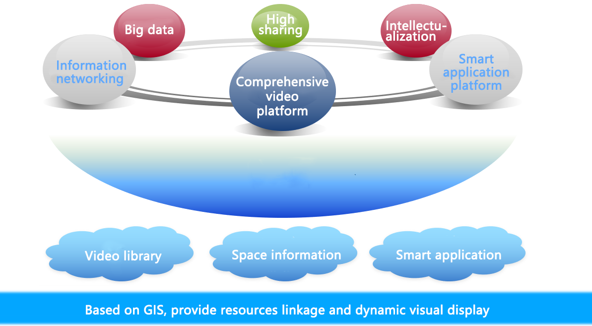
However, at the present stage, the public security video surveillance system and the command and combat system use the traditional matrix window for video viewing, which is often not intuitive enough, and the command personnel cannot grasp the situation on the spot in real time, resulting in low efficiency of emergency command and dispatch. In addition, various business systems used in the daily work of public security, such as video monitoring, personnel and vehicle positioning, mesh police grid, etc., are too separate. In joint operations, commanders need to check relevant information on each subsystem separately, thus reducing work efficiency and lacking a global monitoring video picture for visual display and call of each subsystem, which gives room for the invention of Sample Honzon's HGIS video command platform.
Sample Honzon's HGIS video command platform provides graphic tools for making and displaying plans to ensure the fast and accurate command and dispatch of large-scale activities. It can display real-time signs such as cameras, police forces, vehicles, equipment, materials, commanding heights, fire hydrants, and road closures on GIS maps according to the actual security needs of activities like routes, security defense lines, parking diversion, fire evacuation, video deployment, and specific plans for major emergencies (such as explosions, poisoning, etc.). As for the activities of the possible crowded casualties, explosions, fires, distributing provocative leaflets, as well as major criminal cases of public security incidents, it is urgent to quickly grasp the situation, put into the police force and take measures, so as to implement the targeted policy and quick control. Based on the geographic information service developed by the browser, the system publishes the basic graphic data in the map server into map service data and provides comprehensive map operation functions. It can interface with the information system already established by the public security department. Commanders no longer need to check the relevant information on each system individually. All important information can be displayed visually on the current global monitoring screen, which greatly improves the work efficiency and forms an all-round, detailed and three-dimensional monitoring and commanding system.
Objectives:
Sample Honzon is developing a monitoring and command platform based on GIS in view of the above problems after years of experience in safe city construction. The system is mainly composed of front-end monitoring, network transmission and back-end monitoring and command subsystems. The deployment is done for the two major venues of the tournament:
Main Venue: a set of high-point cameras will be set up in the main venue to access the existing security cameras around, and some low-point cameras will be added to cover blind areas and corners. The high-point cameras holistically monitors road, buildings, vehicles, personnel, etc.
Racecourse: as there have already been some cameras along racecourses, some other cameras can be added to cover blind areas and corners. Based on GIS maps, corresponding video patrol routes are respectively deployed for three racecourses. Access the real-time positioning data of police officers, athletes, medical personnel, guide vehicles, vehicle-mounted videos and handheld terminal GPS, and display the videos and positioning information on all fronts, thus ensuring the real-time, efficient, visual and accurate scheduling of sports competitions.
Command Center: it is the top level for deployment, monitoring and command. Real-time control and emergency shall be handled on all track routes and places.
Solution
1. Infrastructure Level
The infrastructure level is integral for the video system, including: front-end network cameras, digital hard-disk video recorders, switcher, video storage device, video display and other structures.
2. Data Level
The data level is basic for the whole GIS video patrol practice. The whole platform is built with the relevant data.
3. Application Level
The functional level is the concrete embodiment of the relevant data on the GIS video patrol platform. It mainly includes the basic functions and developable functions of GIS platform.
4. User Level
The user layer is mainly for video management server. Different users can define different account clearance.
Advantages
1. The Practical and Efficient "Intelligent Platform" to Improve Users' Security Capabilities
The security command and monitoring platform for large-scale activities is intuitive, efficient, convenient and fast. When an event occurs, the GIS map is used to quickly plan the best rescue and dispatch the nearest police resources. It personalizes security platform configuration, locks in key security targets, and improves the efficiency of comprehensive information query; It renders the visualized correlation of videos, places, police forces, routes, etc. It also provides auxiliary decision-making for security command and dispatch;
2. The Recycling "Green Platform" to Reduce User Construction Costs
A comprehensive video command platform with "one map, multiple information, alarm linkage and spatial analysis" is established by "video monitoring, business data and intelligent video analysis of each part". Through this platform, relevant video information data between departments can be mobilized to improve video utilization and ensure real-time monitoring.
Use of original resources: Make use of the existing network to adjust its architecture and unify the independent video and data information. Fully utilize the original infrastructure and equipment to maximize the utilization rate and save unnecessary expenses.
Improve management efficiency and reduce repetitive investment: through the perfect combination of data, map information and video of each part, make full use of information sharing to effectively avoid blind spots. Advanced, mature and stable technologies and equipment will be adopted. On this basis, appropriate advancement and innovation will be made, with emphasis on the innovation. More diversified, efficient and accurate management and information services will be provided in command and dispatch, video analysis and data linkage.
Rely on the platform to complete a variety of large-scale activities of security tasks, which also functions for the public security or government daily command scheduling use. Wasting one-off resources should be completely abandoned.
3. The "Personalized Platform" to Enhance User Self-Management
Simplify user operations, fully lock interested information, and meet the needs of public security for quick access to information. Provide more accurate and rich videos and related data to support the security work of activities.
Good sharing environment: optimize infrastructure and resource sharing service system, realize information sharing and interconnection, break information silo and drive intensive development of information resources.
4. Fast Response
The number of on-screen previews can be set in advance for video monitoring on GIS. When operating (moving, zooming, etc.) the map, the cameras nearby can respond to previews at an extremely fast speed, opening previews in 0.5 seconds and displaying up to 64 images at the same time.
5. GIS High-definition Map Application
The system uses high pixel aerial photos above 12Cm level and large scale vector maps above 1/1000. Armed with its own GIS engine, it can have fast response.
6. Holistic Linkage and Rapid Control Deployment
The simplified user operation, value information lock and fine visual interface provide a series of personalized settings for users, including not only the general configuration of security platform alarm icon, video grouping, card point grouping, police grouping, but also the personalized configuration of places, routes, layers, activities, etc. In the event of an emergency, it can confirm the location and develop countermeasures quickly, so as to dispatch manpower and material resources to make effective responses and improve the efficiency of command and dispatch.
7. Integrate Resources and Data to Construct a Comprehensive Prevention and Control System.
It is compatible with all mainstream monitoring camera manufacturers at home and abroad, and its system also supports unlimited expansion. All monitoring cameras can be managed through one map.
At the same time, the system can obtain the most valuable operation data, alarm, control information and other resources for on-site command and scheduling through docking with the existing subsystems of the public security. All important information can be displayed visually in combination with the current global monitoring video images, thus greatly improving the work performance.
Typical Cases